
NEWS RELEASE
After review of the DEIS for All Aboard Florida (The Project), we believe it is inadequate. The information regarding Indian River County, Florida and its communities that will be impacted by All Aboard Florida – Sebastian, Gifford, Vero Beach as well as the county along or near the railroad is incomplete.
Support information and appendices are missing from the report. Reputable local historians and cultural heritage experts from Indian River County were never contacted. The DEIS attempts to pass off contacts used in the southern portion Phase 1 of the project (Palm Beach to Miami) as representing and commenting on Indian River County. This is unacceptable, the representation is inaccurate, and the study not at all reflective of our cultural heritage information.
The document is inadequate in addressing primary concerns of the project on our cultural heritage sites, mitigation during demolition and construction of the San Sebastian Bridge, wildlife, social justice and the treatment of the Gifford community, and businesses. Many of the assumptions made in the DEIS are unsupported. Some statements in the report are in conflict with statements made in other parts of the report. Some of what is in the report does not match what has transpired in discussions with All Aboard Florida representatives in our community. For instance, the Gifford community was not told about the impacts the All Aboard Florida project will have in their community.
Indian River County is a “Donor” county to this All Aboard Florida project. There are no direct positive economic benefits to Indian River County, Sebastian, Florida, or Vero Beach, Florida and including the Gifford community.
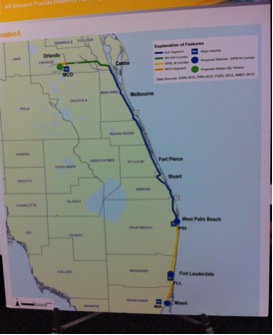
The Indian River County DEIS community meeting held on November 5, 2014 at the Indian River State College, Mueller Center was a representation of those items that All Aboard Florida desired to discuss and not necessarily those items of critical importance to the members of the Indian River County community. The project maps that were displayed by Federal Railroad Administration at this community meeting did not even have the names of the towns in Indian River County that will be impacted by All Aboard Florida project! For the record, those towns are Sebastian, Florida and Vero Beach, Florida.
Photo of map on display at public meeting is shown below:
We urge that the Federal Railroad Administration, the All Aboard Florida consulting firm, and All Aboard Florida principals Final EIS incorporate provisions that will address the issues outlined in this DEIS response document and in every other DEIS response document provided by all agencies, organizations, individuals, and governments in Sebastian, Florida, Vero Beach, Florida and Indian River County, Florida.
COMMENTS AND CONCERNS
From the Summary
S-18 last paragraph, states that “The Project will not adversely affect (“use”) and public parks, recreation areas, or wildlife refuges. Collectively, these properties are protected under Section 4(f) of the department of transportation Act, as are historic properties.” On page S-19 the text continues stating that “The existing N-S Corridor bisects two of these Section 4(f) recreation resources” and names “Hobe Sound National Wildlife Refuge and Jonathan State Park.”
RESPONSE: It fails to recognize that historic Pocahontas Park, the Heritage Center and the Vero Beach Community Center which are all located in an historic park. The document does not include any input from local authorities at Indian River County, Sebastian or City of Vero Beach.
How will the consulting group address the obvious lack of communication with the Cities of Vero Beach and Sebastian, Indian River County government and local knowledgeable organizations and individuals?
S-19 Visual and Scenic Resources states that “veiwsheds along “N-S Corridor would remain primarily unchanged.”
RESPONSE: This area of the document addresses mostly those areas along SR528 while barely noting the railway immediately adjacent to US 1 that runs from Titusville (in Brevard County) through Wabasso (in Indian River County).
See map and information below and on next page of Indian River Lagoon National Scenic Byway which was taken directly from U.S. Department of Transportation, Federal Highway Administration website for “America’s Byways. According to this U.S. Department of Transportation website:
http://www.fhwa.dot.gov/byways/byways/16199/maps
Indian River Lagoon National Scenic Byway
National Scenic Byway • Florida
| Length | 150.0 mi / 241.4 km |
| Time to Allow | Take four hours to drive or two days to enjoy the byway. |
| Fees | There are no fees to drive the byway; however, some of the state and federal lands charge park fees. |
The Indian River Lagoon National Scenic Byway gives access to a National Estuary providing habitat to more species than anywhere in North America. History buffs, bird watchers, anglers, surfers, swimmers, boaters, and vacationers will find excitement at a national seashore, wildlife refuges, state park, museums, the Kennedy Space Center, beaches, and waterways.
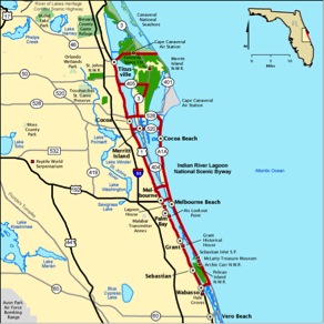
Continued Response: Our County’s economy is deeply rooted in a thriving eco-tourism industry. The Indian River Lagoon is a tourism generator from activity on the lagoon itself to the Scenic Byway mentioned here. According to Florida Atlantic University Harbor Branch, the lagoon “stretches along 40% of Florida’s east coast and yields an estimated $3.7 billion annual economic impact for the state.”
- All of the above information should be included in the EIS.
- “viewshed” impacts should be acknowledged and mitigation named.
Section 4: Affected Environment
Land Use and Transportation
Section 4 Appendices have been omitted from the DEIS.
- Why?
- How will this be corrected?
- Public opinions on certain sections are difficult to make without appropriate support information.
Omitted appendices:
- 1.1-A Existing land use maps
- 1.3-A USCG cooperating agency acceptance
- 1.3-BUSCG jurisdictional determination
- 1.3-C Navigation discipline report
- 2.4-A Potential contaminated sites aerial photographs
- 3.1-A USCG Coordination meeting notes August 12, 2013
- 3.3.-A Characteristic plant species
- 3.5-A EFH assessment
- 3.6-A Rare species survey reports rare species consultation areas
- 4.2-A Minority populations
- 3.6-B Poverty populations
- 4.5-A SHPO consultation materials
- 4.5-B Cultural resources proximate to the project corridor
- 4.6-A Noise and vibration contours
Physical Environment
4.3.3 Natural Environment/Wetlands
The DEIS does document direct and indirect impacts to wetlands, protected species, and habitats.
RESPONSE: However,
- the DEIS is inadequate for proper review because no N-S Corridor FLUCCS maps or habitat and wildlife impact area maps were provided at a proper scale to verify conflicts between the proposed railroad improvements and the habitat type or associated species.
- There was no wetland maps shown to verify were track expansions and passing lanes would conflict with isolated wetlands.
4.4.5 Cultural Resources
Table 4.4.5-2 Certified Local Government/Local Informant Contacts Regarding Potentially Locally Designated Cultural Resources.
RESPONSE:
- No one from the public or private sector in Indian River County, City of Sebastian or the City of Vero Beach was contacted for information regarding cultural resources.
- County authorities were completely overlooked.
- This table names Brevard, St. Lucie and Palm Beach County only.
- This is incomplete and inadequate information.
- Who will be contacted in Indian River County to provide this information?
- How will the consultants incorporate this information into the EIS?
Further, 4-122 states “Normally, archeological and other below ground resources will be affected by ground disturbing activities…” as compared with above ground and that survey methods differ because of those differences. At the bottom of 4-122 it addresses the N-S Corridor and says” the Area of Potential Effect was limited to the footprint of subsurface activities within the existing approximately 100 foot wide FECR Corridor. The historic resources APE included the N-S Corridor as well as 150 feet on either side of the N-S Corridor to allow for consideration of indirect impacts.”
RESPONSE: *Archeological Site Significance: The Old Vero Ice Age Site is west, east and under the FEC tracks. Recent excavations by Merceyhurst at a location immediately adjacent to the railroad have uncovered meaningful artifacts and information from the “Vero Man” Sites that continue to support that people and a large variety of extinct animals were in Vero 12,000 to 14,000 years ago. The local continued archaeological activities are essential for providing further information about the earliest inhabitants of the world as well as Florida. In the future, we believe the positive impact on the scientific community, as well as on Florida, Vero Beach and the region, will be profound.
This archeological site has been found eligible as a national historic site. The site will also most likely be considered as a potential World Site as a bone etched with a mammoth found near this site and was authenticated to be over 12,000 years old demonstrating that humans and animals coexisted in Florida during prehistoric times. The art has been declared by top anthropologists as the “oldest, most spectacular and rare work in the America’s.”
Other archeological findings have been made at additional sites along the FEC tracks going northward from the Merceyhurst site at the Main Relif Canal through Gifford (“Gifford Bones” site) and into Sebastian.
Plans for this AAF project have not been developed to a point where our community can comment. As a result, we do not know what impacts there will be on specific archeological sites. For instance, there has been no bridge plan for the area at the location of the Old Vero Ice Age Site.
- The “Gifford Bones” site is not addressed or identified. Therefore no mitigation is issued. Should be included in the report.
- Impacts and the mitigation of impacts from All Aboard Florida on these areas is not addressed but instead completely overlooked or ignored. Site identification, impacts of All Aboard Florida laying added tracks and the additional vibration and mitigation of same needs to be noted in the final report.
- Other sites along the track ridge are known. How will these important sites be accessed for archeological study?
- Sites along the canals and the bridges are at most risk. How will these be handled during Phase 2?
- How do we make further comments about this if the bridge plans for the location of this archeological site are not complete and available to the public?
- How will information about the archeological sites in Indian River County be included in the EIS?
COMMENTS
4.4.5.1 Methodology
Page 4-124
Consultation
This page recounts meetings between AAF and SHPO. It appears there were several determinations established:
- March 28, 2013 SHPO meets with AAF and determines that the need to coordinate with historic preservation planning representatives for the West Palm Beach to Orlando phase of the project “was not warranted.”
- DEIS states that five public “scoping” meetings were held and that those meetings “provided adequate opportunity for consultation.”
- “SHPO determined that no additional separate Section 106 meetings were necessary.”
- Evidently “scoping” meetings were held in other counties but not in Indian River County. And, in Indian River County there were no public notices for “scoping” meetings outside our county.
- Appears the only archeological site identified in the DEIS in the way of the Project is located in Hobe Sound National Wildlife Refuge.
- We learned that Janus research contacted five CLGs and local informants. NONE in Indian River County. We understand these “determinations” went on before the DEIS was released.
Response: Indian River County was completely ignored in this part of the process. Local representation was totally dismissed without further consideration or notification to local representatives. There were no “scoping” meetings held and no publicly advertised “scoping” meetings in Indian River County while there were dozens of such public notices in Ft. Lauderdale, Orlando and Miami. This oversight completely undermines this part of the Section 106 (National Historic Preservation Act), Section 4(f) Federal Transportation Act, and the EIS process.
- How will FRA and AAF address and correct this oversight?
- How will Indian River County be included at this point in the overall DEIS process?
- It appears that, at the highest levels, the “standard” NEPA process was somehow mixed with the “integrated” method. To our knowledge, this is the first time this has been done. Why?
- We are very concerned about the lack of outreach to [only] CLGs and [certain] local informants and believe this denigrates the DEIS process and intent of benchmarked historic preservation guidelines.
Section 5: Environmental Consequences
Land Use, Transportation and Navigation
5.1.1 While the DEIS indicates little or no adverse impacts and states that Indian River County supports efforts for passenger rail,
RESPONSE: It does not indicate the passionate opposition Indian River County Government, Sebastian City Government, Vero Beach Government, and others have for this project which is not simply about “passenger” rail service but also to deliver increased freight services and the impacts of that freight service on the community.
- Indian River County adopted a resolution opposing All Aboard Florida and does not believe the Project fits into the planning for this community.
- Indian River County Chamber of Commerce endorses the County’s resolution opposing the project.
On page 5-5 the DEIS states “The MCO Segment and N-S Corridor under the Action Alternatives would not bisect any privately owned properties…” RESPONSE: However, the project will completely bisect the City of Vero Beach, its residents and its medical and business services.
On page 5-6, Table 5.1.2-1 regarding grade crossings refers to the highest volume intersections in Indian River County at Oslo Road and SR 60 east and west. Page 5-12, Table 5.1.2-4 indicates that passenger rail will travel at 106.6 mph through Indian River County which includes these 3 highly traveled intersections/crossing. Page 5-8 mentions that freight will see an increased length in trains but states that there will be “minor” roadway closures and “minimal” impacts to existing conditions.
RESPONSE: These statements fight with one another and it is clear there will be significant negative impacts to crossings themselves, delays in traffic due to crossing closures, and significant impacts all of the above will have on our residents, public safety equipment, employees, goods being transported, school bus and Senior Resource GoLine public bus schedules, and visitors traveling east and west in our community.
Although the DEIS is triggered only by the All Aboard Florida passenger rail request for a RIF loan, the DEIS does note that FEC freight traffic (once the FEC line is double-tracked and the Panama Canal is opened) will increase. Vibration levels as indicated in the Table 5.1.2-4 clearly state that current number of freight is 22 per day traveling at 54.2 mph and the proposed passenger will be 32 trains per day t(to start) at 106.6 mph.
- The vibration issue should reflect the identification of the additional freight and mitigation measures should be identified.
Senior Resource Association public bus GoLine: Increased rail crossing closures may present an obstacle in adhering to transit schedules.
- Will FEC and All Aboard Florida be required to coordinate with all public and private local fixed route providers in the corridor to minimize these impacts?
48% of Indian River County population is over the age of 50. Increased rail crossing present a concern for this population to be on time for medical appointments. There is an added risk component to rail crossing since the horns will be on a static pole with reduced horn sound. Individuals with decreased hearing abilities and other handicaps will be at a greater risk in an attempted crossing when a train is approaching.
- How will this disability issue be handled by AAF? There is not mention in the DEIS.
Physical Environment
5.2.2 Noise and Vibration
Page 5-39 states there will be “minor vibration impacts along the N-S Corridor due to the increase (approximately doubling) of vibration events as a result of adding passenger train service to the existing freight operations.”
RESPONSE: This is not accurate. Existing freight today is 8-10 trains daily. Add to 32 proposed N-S passenger trains totals 40-42 trains daily. Table 5.1.2-4 on page 5-12 shows clearly that by 2019 there will be 22 freight trains daily. That does not even consider the number of trains following the opening of the Panama Canal and even more trains to accommodate the Port of Miami.
- Using the number reflected in Table 5.1.2-4 the total trains daily would be a minimum of 52 trains (not 42 as stated)
Along the Vero Beach section of the tracks, the Indian River County Chamber of Commerce has a new (C.O. 2009) 2-story, $1.5 million structure used a community visitor center and business center. There are also multiple cultural historic facilities/tracts which include the Old Vero Ice Age Site (*archeological site), the historic Vero Beach Train Station, Heritage center building, and the historic City of Vero Beach electric plant. The argument we have heard is that these structures are already impacted by train traffic. However, today that traffic is 8-10 trains each day not 42 or more which will put additional vibration on these structures.
- How will new and old structures be impacted by the additional vibration from the increased number and length of freight trains as projected in the DEIS document?
As stated above in the 4.4.5 response –
*Archeological Site Significance: The Old Vero Ice Age Site archeological excavation site is immediately adjacent to the FEC tracks on the east side. However, the archeological site itself is east, west and under the existing track bed. Recent excavations have uncovered meaningful artifacts and information from the “Vero Man” Sites that continue to support that people and a large variety of extinct animals were in Vero 12,000 to 14,000 years ago. The local continued archaeological activities are essential for providing further information about the earliest inhabitants of the world as well as Florida. In the future, we believe the positive impact on the scientific community, as well as on Florida, Vero Beach and the region, will be profound.
This archeological site has been found eligible as a national historic site. The site will also most likely be considered as a potential World Site as a bone etched with a mammoth found near this site and was authenticated to be over 12,000 years old demonstrating that humans and animals coexisted in Florida during prehistoric times. The art has been declared by top anthropologists as the “oldest, most spectacular and rare work in the America’s.”
There are additional documented archeological sites located in the northern, northeastern and mid sections of Indian River County. The DEIS has not dealt at all with any archeological finds in Indian River County. And there have not been contacts made with those in Indian River County who are knowledgeable to comment.
- How will the consultant address the remaining archeologically significant sites within Indian River County and describe mitigation of damages to those sites?
- Other response questions on this topic are named in response above 4.4.5
Natural Environment
5.3.6.2 Environmental Consequences
It is specifically stated that “scrub jay meta-populations were not fully evaluated.”
RESPONSE: Scrub Jays are vulnerable to mortality due to collisions with moving vehicles. This is inadequate for proper review and decision making. Habitat loss, incidental take, and mitigation should also have been discussed.
- Why wasn’t this information fully evaluated?
- It is necessary that the Final EIS and the All Aboard Florida project substantively address Scrub Jay mortality and incidental take due to collisions with train sets in the Final EIS?
The DEIS relies on mitigation banking for wetland impact compensation.
- There are not available mitigation banks in all water management basins, therefore if there are areas of isolated wetland impacts in some areas of the project no mitigation is available as proposed.
- This is inadequate and lacking in information as presented.
5.3.3 Wetlands
Page 5-81-91
This section addresses and identifies wetland governing regulations and discusses the types of impacts. Several instances where it states minor or no impacts.
RESPONSE:
- The consultant needs to address/confirm available appropriate wetland mitigation banks for each wetland type per impact basin individually.
5.4 Social and Economic Environment
Page 5-48 states in the first paragraph that the project will result “in an increase in future noise levels and the potential for noise impacts.”
RESPONSE: It is our opinion that this will result in increased difficulty to maintain and operate businesses efficiently and effectively at or within 100 feet of all crossings/intersections of the railway. The increased noise and vibration will be coupled with additional noises and vibrations from sounds emitted from the wayside horns.
- There are no maps available and no back up provided in the DEIS that demonstrate the amount of land owned by FEC.
About 100 yards from the US 1 Ponce de Leon intersection in Vero Beach are over 150 residents, mostly elderly who will also be inflicted with noise from the wayside horns.
The DEIS further states that “the Project will not displace any businesses (page 5-127)” and that the “Project would have beneficial regional economic impacts from increased economic activity, tax revenues, construction jobs, and associated spending.”
RESPONSE: Economic Impact:
As an example, the pet store (Cindi’s Pet Center) located at 721 US 1, Vero Beach is immediately adjacent to the 7th Street crossing. The shop will most likely need to be relocated or will close due to the increased noise and vibration impacts on fish, reptiles, birds and dogs.
5.4.1 Communities and Demographics, 5.4.1.1 Environmental Cosequences
Page 5-121 of the DEIS states that “would not result in residential displacement, neighborhood fragmentation or loss of continuity between neighborhoods.”
RESPONSE: While this statement may be true in 2014, Table 5.1.2-4 clearly shows an increase to the total number of trains to 54 daily in 2019 (4 years from now). This table also shows that the 32 passenger trains are moving through Indian River County at speeds over 106.6mph and freight at 54.2 mph in 2019. Of particularly concern are the elderly drivers and those who depend on foot or bicycle to cross over the tracks to get to medical appointments and go to their place of employment.
- The argument that the rail line has already been in place and creates no changes simply is not acceptable when both the number of trains and the speed at which they will travel more than doubles by FEC estimates by 2019. Does not compare apples to apples.
- How will these facts presented in the DEIS (above) not change neighborhood continuity?
- What will be the impact on property values and desirability of neighborhoods near the tracks?
5.4.1.2 Indirect and Secondary Impacts
On page 5-123 the DEIS the writer describes population and transit growth in South Florida. It goes on to state that All Aboard Florida would be an improvement to address roadway congestion and increase the ability to transport people between major South Florida cities.
RESPONSE: This section only addresses issues from West Palm Beach through Miami. Statements made in 5.4.1.2 do not reflect the northern Phase 2 past of the project. While this may be true between Palm Beach and Miami, it is not at all factual for Brevard, Indian River, St. Lucie and Martin Counties. There are no stops in any of these four northern route counties. These four counties are “donor counties” with no immediate or near-future consideration for any benefit but will encounter tremendous loss of mobility, peace and quiet and quality of life with an additional 32-passenger trains and estimated doubling of freight.
5.4.2 Environmental Justice
Page 5-123 it is stated that this section describes the potential effects to minority and low-income populations Page 5-121 of the DEIS states that “would not result in residential displacement, neighborhood fragmentation or loss of continuity between neighborhoods.”
RESPONSE: Again, this statement does not hold up and will no longer be factual when an additional 32 passenger trains a day are blowing through Indian River County at speeds of 106.6mph in 2019. (Table 5.1.2-4)
According to the local history book “Hibiscus City”, When Henry Flagler built the rail line there was a dispute with the John T. Gifford family over land Flagler wanted for his railroad. To retaliate for the delay of the desired rail extension, Flagler’s surveyors named a small labor camp, an exclusive Negro community, “Gifford.” Today, Gifford remain a largely non-Hispanic black and low-income population (average annual wage $20,373 2012 U.S. Census) with many struggles. The area has maintained 2 and 3 tracks and is the only area of Indian River County that continues to see long delays from stopped trains.
Within yards of the tracks through Gifford are-
- a number of homes within 50-yards of the tracks,
- nearby schools,
- a medical center,
- and businesses and employment located in close proximity to the railroad tracks.
The additional passenger and freight trains that are anticipated will have an increased negative social impact on this small black community and as stated on page 5-48 of the DEIS in the first paragraph – “this project will result “in an increase in future noise levels and the potential for noise impacts.”
Representatives of the Gifford Progressive Civic League are very concerned about the additional trains, both freight and passenger, and the on-going impact this will have on all emergency services to and from their small community. Currently, this area of the county already has more than one track and experiences longer delays and trains stopping than is experienced in other parts of Indian River County.
Neighborhoods within the Gifford community, and for that matter elsewhere in the County, have developed their own “unofficial crossings.” A number of school children considered “walkers” cross the tracks to attend school in Gifford.
- How will the DEIS and AAF address these “unofficial neighborhood crossings”?
Children have been fascinated with trains and speed for decades. Starting with “Thomas the Train” children love trains! Children within any part of our community have grown accustomed to the speed of the local freight trains. They can judge their “timing” with approaching freight trains moving 35-45 mph. It is a fact that looking down the tracks it is extremely difficult for pedestrians to judge how quickly the passenger rail will approach going speeds 80-100mph and faster.
There is nothing in the DEIS that we can find that describes how AAF will provision for safety in these crossing areas. It is recognized that all areas along the tracks can not be fenced.
- How will AAF accommodate for children and other pedestrians in those “unofficial pedestrian crossing” areas?
In order to comply with the Civil Rights Act of 1964 and the Federal desegregation of schools, school districts are divided by zones. Gifford children are bused (long-runs) to accommodate Federal desegregation regulations and to raise the numbers of African American children attending other neighborhood schools. This causes a disproportionate effect to Gifford students more so than other neighborhoods outside of the Gifford community. Intersections at 45th and 49th Streets are of concern because the children are bused over these intersections twice daily in order to reach their designated out of neighborhood school for Federal compliance reasons.
- What special care will be used by AAF at those intersections to mitigate for the possibility of accidents with school buses?
5.4.3 Economic Conditions
While the DEIS page 5-127 says the Project will not reduce municipal property taxes that is yet to be seen. The DEIS only addresses properties acquired by AAF.
RESPONSE: Florida East Coast and All Aboard Florida are not in the position to determine if property values or property taxes would decrease. Property values are driven by the marketplace which will determine what the private sector will be willing to pay for properties near the tracks and that will have an impact on those privately owned properties.
The DEIS further states that “the Project will not displace any businesses (page 5-127)” and that the “Project would have beneficial regional economic impacts from increased economic activity, tax revenues, construction jobs, and associated spending.”
RESPONSE: This is a broad and generalized statement in which the DEIS consultant is referring to the southern portion Palm Beach to Miami segment of the N-S project corridor.
- This statement does not apply to Martin, St. Lucie or Indian River Counties.
There are no stops, no appreciable economic activity, no tax revenues, no jobs, and no appreciable associated spending that will occur in Indian River County. All increased economic activity and the benefits from such activity will occur from Palm Beach to Miami. And all employment from additional laying of tracks, in all areas of the project are temporary.
The results of a recent survey of our Chamber of Commerce membership shows that-
- 68% of our businesses believe their business operations will be negatively impacted by the Project.
- 4% believe that their customers coming to their business will be negatively impacted.
- 3% strongly oppose All Aboard Florida
“…freight traffic on the FECR (Florida East Coast Railroad) Corridor is predicted to increase. FECR operated 24 daily trains in 2006 and had projected growth of 5-7% between today and 2016. However, due to delays in the expansion of the Panama Canal and other factors, it is now expected that freight operations will increase from the current number of trains (now 8 to 10 daily) to 20 trains per day by 2016, and at a 3% annual growth after 2016.”
RESPONSE: 71% of business survey respondents say the added 32 passenger train a day will have a negative impact on our country.
Some comments from our business members-
- “If these statistics are accurate I believe it will increase traffic and wait times for east/west motorists.”
- “Rail service is key to the success of any port – you can’t move boats on land. So I believe that this really is about increases in freight. They won’t run 32 passenger trains a day if only a dozen or so people are on them.”
- “Traffic to and from my store will be held up numerous times daily as the trains pass thru Vero.”
- “My business property is next to the RR tracks — Noisy — distracting — DANGEROUS to allow 100+ MPH train where 55 MPH is currently the speed limit. 55 MPH is fast enough.”
- “Time allowances getting to and from our clients will be negatively affected for all outbound business associates.”
As stated earlier-
RESPONSE: Economic Impact:
- As an example, the pet store (Cindi’s Pet Center) located at 721 US 1, Vero Beach is immediately adjacent to the 7th Street crossing. The shop will most likely need to be relocated or will close due to the increased noise and vibration impacts on fish, reptiles, birds and dogs.
Table 5.4.3-1 Summary of Economic benefits-
Page 5-128 under Action Alternatives A, C, and E states “The Project would increase fede5ral, state, and local government revenues and have other direct economic benefits to local populations.” (References Washington Economics Group)
RESPONSE:
- There are no direct economic benefits to Indian River County.
- The information in this table is inadequate and does not support a “direct economic benefit” at local levels for those counties that do not have a stop or long-tern employment relating to the Project.
- We recommend that the consultant provide a similar table showing the DIRECT benefits county by county from “increased economic activity, tax revenues, construction jobs, and associated spending” as stated on page 5-127 of the EIS.
5.4.5 Public Health and Safety
This section addresses removing cars from highways i.e. “fewer vehicle crashes and fewer air emissions” page 5-131.
RESPONSE: Our business community survey respondents reported that-
- 1% stated that the Project will create vehicle and pedestrian safety issues
- 4% have concerns about emergency services access.
- 4% local ability to deal with potential rail accidents.
5.4.5 Cultural Resources
Page 5-137, bottom of page, states “The Project would have no direct or indirect effects (noise, vibration, change in setting) to the historic resources located adjacent to the N-S Corridor. It further states, page 5-138, that “All cultural resource investigations were conducted in accordance with Section 106 of the NHPA and its implementing regulations for protection of Historic Properties (36CFR part 800).” And ends with “The methodology for the balance of the N-S Corridor was consistent with that used in the 2012 EA.”
Response:
- The above referenced paragraph describes how the MCO segment and the E-W Corridor was addressed by SHPA in consultation with FRA. It refers to the EA which was done for Phase 1 West Palm Beach to Miami not Phase 2 Martin County through Brevard County.
- This is inadequate as Pahe 1 and Phase 2 are not equal comparisons but very dissimilar.
In Indian River County there are the Old Vero Ice Age Site and other archeological sites as already reported. Historic sites including the Holstrom property (house and barns), and others.
- Halstrom property (house and barns) on National Register of Historic Places
- No one from Indian River County was consulted for information.
- In the “North-South Corridor” info, no mention of sites in Indian River County.
- Appears all communication was with SHPO.
- Why was no one contacted in this part of Pahe 2? On page 5-141 it notes Phase 1 of the project from Miami to West Palm Beach.
- Hobe Sound and Fort Capron mentioned but no sites in Indian River County.
- This section is incomplete and inadequate.
Not acknowledged or discussed in the DEIS:
- Old Town Sebastian Historic District East*
- on National Register of Historical Places (2003).
- Old Town Sebastian Historic District West*:
- on National Register of Historical Places (2004)
- Why were impacts of vibration, noise, safety, and viewsheds not included in DEIS?
Section 6: 4(f) Evaluation
6.4.2 St. Sebastian River Bridge The applicant indicated the Sebastian River Bridge Table 1-1 is located in Brevard County.
RESPONSE: The bridge is also partially located in Indian River County and will have environmental impacts in Indian River County.
- Demolition and construction impacts should be addressed.
A shell midden site is reported in or adjacent to this bridgehead.
- How will AAF work in and around this archeological site?
This bridge is determined eligible for NRHP by SHPO
6.4.1.4 Measures to Minimize Harm and Mitigate Impacts
This section discusses AAF will conduct historic research, prepare an Historic American Buildings Survey, Historic American Engineering Record and consult with SHPO prior to demolition.
RESPONSE: The St. Sebastian River is a tributary of the Indian River Lagoon. The Indian River Lagoon has for the last several years been the issue of highest importance to all the N-S corridor counties from Brevard through Martin County. Any construction of new bridges to replace the existing historic structures will cause unintended negative ecological impact to the San Sebastian waterway and its habitat for fish and other wildlife in the vicinity. Therefore, will have negative impact on the Indian River Lagoon.
For the sake of those in our communities who are concerned about environmental impacts that will include negative impacts on our eco-tourism, this section of the EIS should include a detailed description of how AAF will mitigate environmental damages to the river bottom, fish and wildlife habitats in and around the bridge location and how mitigation and minimization of harm will be handled during all phases of bridge construction.
Areas of the EIS rely on mitigation banking for wetland impact compensation. There are not available mitigation banks in all water management basins. For instance, the eastern part of Indian River County is in Basin 22 St. Johns River Water Management District and has no freshwater wetland mitigation bank currently operating. There is not a currently authorized Basin 22 mitigation bank, and so there are no mitigation credits available to offset impacts to freshwater wetlands within this basin.
If there are areas of isolated wetland impacts in some areas of the project no mitigation is available as proposed. This is inadequate as presented.
See map inserted below:
This section of the report should reflect that it can reasonably be expected that adverse impacts to manatees will result from St. Sebastian River bridge demolition/construction, as well as the increased frequency and speed of proposed AAF rail traffic. The C-54 canal (historic West Prong of the St. Sebastian River) is a major warm water aggregation area for manatees; thus, the bridge site is in an area of high manatee use. The DEIS states that during demolition and construction of the St Sebastian Bridge, siltation barriers will be used around the construction site that would not impair manatee movement.
- Additional mitigation and caution may be required to allow the manatees to access warmer water in the event of cold weather.
- An aerial overlay should be provided onto the Track Chart 3.3-B4
- When asked at the public meeting held in Indian River County “how will mitigation be described in the final EIS?, the consultant at that station indicated “all of this will be addressed in the project permitting process.” That means he expects this to bypass the EIS and go straight to permitting further demonstrating that the public meeting was no more than an FRA dog and pony show. This should be addressed in the EIS.
Demolition and Construction Noise: When source levels are greater than the thresholds, there are impacts to the organisms. That can be calculated and should demonstrate the distances to which those effects may extend.
- How will noise vibrations via water be addressed and mitigated for in regard to damages to habitat and breeding of species of fish and breeding within this waterway?
- What are the statistics of the level of noise and vibration carried from the bridge construction areas in the St. Sebastian River into the Indian River Lagoon?
- How will AAF research and accommodate for cumulative sound exposure from pile driving noise and vibration during the construction of the new bridge?
- How will AAF determine if noise from the installation of piles has the potential to negatively effect fish, turtles, and manatee?
- How will these source levels be compared to known thresholds?
- How far will the harmful noise and vibration travel before attenuating below threshold values?
- Please gather information and explain in the EIS: How will rust from the demolition will be mitigated?
Section 7: Mitigation Measures and Project Commitments
7.2 Project Commitments
7.2.11.1 West Indian Manatee Mitigation Measures
RESPONSE: This section of the report should reflect that it can reasonably be expected that adverse impacts to manatees will result from St. Sebastian River bridge demolition/construction, as well as the increased frequency and speed of proposed AAF rail traffic. The C-54 canal (historic West Prong of the St. Sebastian River) is a major warm water aggregation area for manatees; thus, the bridge site is in an area of high manatee use. The DEIS states that during demolition and construction of the St Sebastian Bridge, siltation barriers will be used around the construction site that would not impair manatee movement.
- What additional mitigation and caution will be utilized to allow the manatees to access warmer water in the event of cold weather?
- How will the manatees be protected from rust and other debris that may come from the demolition of the existing bridge structure?

The DIS also does not address the impact on people who might be literally on the wrong side of the tracks in the event of a medical emergency. The train situation as it exists today can have a detrimental impact on anyone who has suffered a heart attack or stroke. The medical community calls the time immediately after a medical episode as the “golden hour.” The failure to get immediate help after the “golden hour” can have a long term negative impact on a patient..
Intentionally adding to the time to obtain medical care is just a case of lack of common sense. I may be old fashioned but I think that getting my husband to the emergency center is more important than some corporation making money with frequent rail shipments coursing through our community. My husband has already survived one heart attack. I do not think that he should have to wait for a train to pass prior to getting the medical care that he would need in the event of another heart attack.
I would like the medical community to have input to the DIS.
Who or what is the Chamber that compiled this response to the DEIS? It’s a great commentary, but who put it together?
Elizabeth, This report was prepared and released by the Vero Beach/Indian River County Chamber of Commerce. It did not occur to me to be more specific.