
NEWS
This is an important message from ALERT Indian River
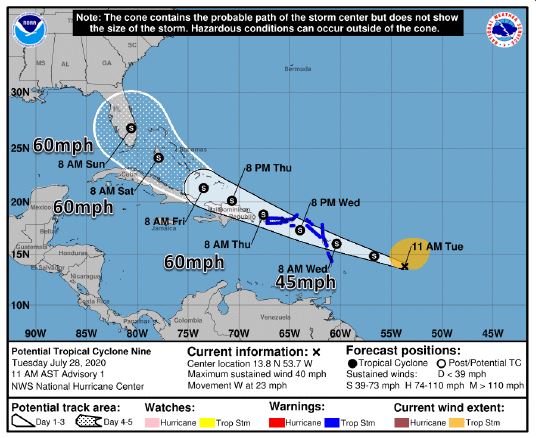 The National Hurricane Center is currently issuing advisories on Potential Tropical Cyclone Nine (Formerly Invest 92L). PTC 9 is currently located about 400 miles east of the Windward Islands and is forecast to strengthen to a tropical storm tonight or Wednesday before reaching the Leeward Islands. The system will be near Puerto Rico Thursday, the Bahamas on Friday, and south Florida on Sunday. The next name on the list is Isaias (ees-ah-EE-ahs).
Current Information:
- Center Location: 13.8° N 53.7° W
- Maximum Sustained Wind: 40 mph
- Movement: West at 23 mph
As you can see by the attached graphic, most of Florida is in the 5-day potential track but there is high uncertainty with the forecast track and intensity.
Possible impacts to our area:
- PTC #9 does pose a direct threat to Florida starting on Sunday.
- Heavy rainfall and gusty winds (35-55 mph) are becoming increasingly likely.
- Hazardous sea conditions
If you have not done so already, please use this time to:
- Review your disaster plan.
- Build or restock your disaster supplies kit.
- Gather important papers.
- Review the Official Disaster Preparedness Guide for Indian River County by clicking on this link: https://www.irces.com/EM/documents/Disaster-Preparedness.pdf
